This is the introductory page. Here you can find some basic information about the API.
For API documentation, visit /docs.
# Import necessary libraries
import pandas as pd
import json
import requests

# Define the file path and read the CSV file

filepath = r"example\L111A_fm.csv"
df = pd.read_csv(filepath)
dataframe = df.to_dict(orient="records")

#or get the example dataframe from the API
r=requests.get("https://nogeo-geotolkapi.azurewebsites.net/example_dataframe_fm")
df=pd.read_json(r.json())

# Convert timestamp columns to string format
df['created_at'] = df['created_at'].astype(str)
df['updated_at'] = df['updated_at'].astype(str)
dataframe = df.to_dict(orient="records")


# Define the parameters for the API request
params = {
    "max_layers": 2,
    "min_depth_layer": 0.5,
    "classify_bedrock": True,
    "plot_proba": True,
    "smoothing_depth_layers": 1,
    "convertLayersStandard": True,
    "from_geotolk": True,
    "writeWhere": "Somewhere",
}

# Define the metadata for the API request
metadata = {"x": 0.0, "y": 0.0, "z": 0.0}

# Prepare the payload for the API request
payload = {
    "params": params,
    "dataframe": {
        "data": dataframe,
    },
    "metadata": metadata,
}
payload = json.dumps(payload)

# Define the API URL and headers
API_URL = "https://nogeo-geotolkapi.azurewebsites.net"
headers = {
    "Content-Type": "application/json",
}

# Send the POST request to pred the FM dataframe
response = requests.post(
    API_URL + "/pred/fm_dataframe", data=payload, headers=headers
)

#If original csv/dataframe is on the format of FGD, use the following endpoint
response = requests.post(
    API_URL + "/pred/fgdb_dataframe", data=payload, headers=headers
)

# Process the response
if response.status_code == 200:
    response_data = response.json()
    tlk = pd.DataFrame(response_data["TLK"])
    display(tlk)
else:
    print("Error:", response.status_code)
    print(response.text)
The response from the API is structured as follows:
from pydantic import BaseModel, root_validator
from typing import List, Optional

class TLKItem(BaseModel):
    start: float
    stop: float
    type: str
    probability: float
    manual_label: int
    input_filename: str
    kote: float
    max_depth: float
    x: float
    y: float

class QUICKCLAYItem(BaseModel):
    start: float
    stop: float
    type: str
    probability: float

class STATIC_DATAItem(BaseModel):
    Dybde: float
    Udrenert: float
    Drenert: float
    Harde_masser: Optional[float] = None
    Trykk: Optional[float] = None
    Spyletrykk: Optional[float] = None
    Oekt_rotasjon: Optional[float] = None
    Spyling: Optional[float] = None
    Bortid: Optional[float] = None
    Slagboring: Optional[float] = None

    @root_validator(pre=True)
    def rename_keys(cls, values):
        if "Harde masser" in values:
            values["Harde_masser"] = values.pop("Harde masser")
        return values

class SND_METADATA(BaseModel):
    x: float
    y: float
    z: float

class ResponseGeotolk(BaseModel):
    SND_METADATA: SND_METADATA
    STATIC_DATA: List[STATIC_DATAItem]
    TLK: List[TLKItem]
    QUICK_CLAY_LAYERS: Optional[List[QUICKCLAYItem]] = []
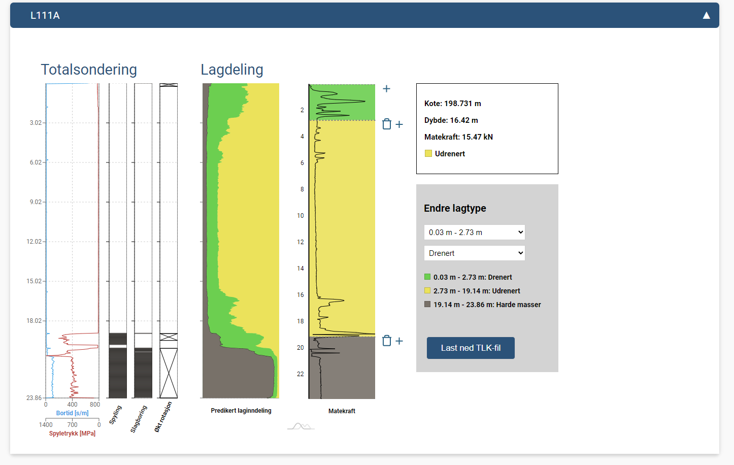
This response model includes several components:
SND_METADATA: Metadata including coordinates.STATIC_DATA: A list of static data items containing the probability of each layer along the depth, its shown on the "Lagdeling" plot on the picture belowTLK: A list the layers that geotolk predicts given the input parameters. Based on the input parameters, like min_depth_layer and smoothing_depth_layers, the layers will change, since its the sum of the largest proability .QUICK_CLAY_LAYERS: An optional list of quick clay items from probability, this is a beta test for finding possible quickclay layers in a sounding.Here is an image that visually represents the response structure: